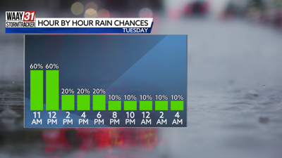


Widespread showers and a few thunderstorms will continue to move south and east through North Alabama and Southern Tennessee throughout the rest of lunchtime.
The risk for severe weather is low, but heavy rain and gusty winds may slow down your lunchtime drive. Localized ponding on roads and decreased visibility are our biggest concerns.
Rain coverage dwindles as we head later into the afternoon hours. High temperatures will be cooler and in the upper 80s due to rain and dense cloud cover.

A cold front sweeps through North Alabama tonight, providing brief relief in the humidity. Highs still reach the low 90s Wednesday and Thursday, but drier air keeps our forecast sunny and comfortable! Humidity creeps back in by Friday. Scattered storms may put a damper on your Labor Day weekend plans as a result.
TUESDAY: Showers and storms this morning, drier by the evening. Highs in the upper 80s. Chance of rain: 60%. Wind: SE 5-10 MPH.
TONIGHT: Partly cloudy. Lows in the upper 60s. Wind: N 5-10 MPH.